


![]()
A poorly-understood Marconi wireless station is brought to life by an amateur archaeologist and radio enthusiast
In 1913, great iron pinnacles of a Marconi wireless telegraphy station started to grow to the east of Caernarfon, north Wales. Within a year, the wild slopes of Cefn Du Mountain, near the foot of Yr Wyddfa (‘Snowdon’), had been transformed into a site hosting the very cutting-edge of ‘transocean’ wireless technology.
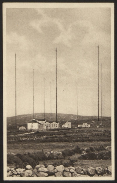
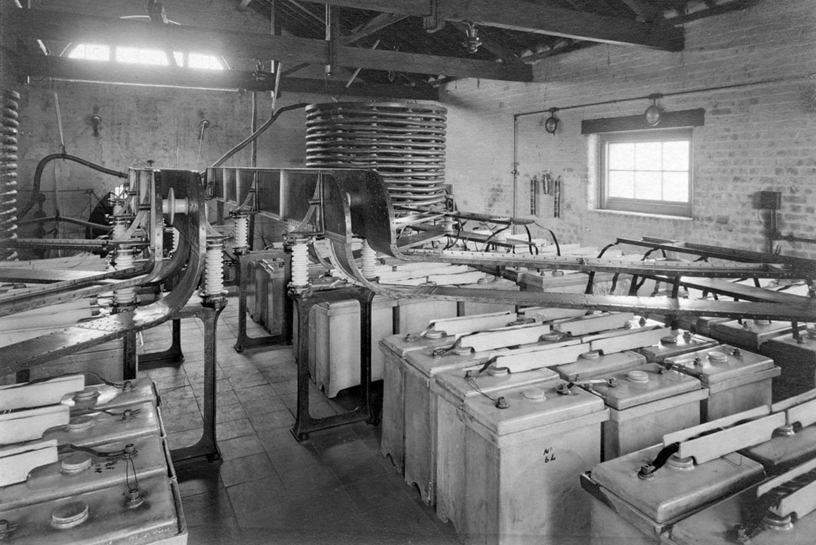
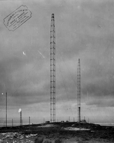
Then universally known to the Marconi company as the (anglicised placename) of ‘Carnarvon’ station, ten 400-foot (122m) sectional iron tube masts held aloft the 32 wires of a roughly 3847’ (1173m)-long ‘inverted-L’ antenna. The antenna at this stage consisted of a roughly 752m sloping section from the transmitter hall, running up to steel ropes (‘triatics’) strung between the first line of three masts, the rest of the length being gentlysloping, horizontal wires running up the slopes of Cefn Du. It operated under the callsign of ‘MUU’, initially with a simple spark transmitter using 27kHz during the day, 52kHz at night.
Carnarvon’s big claim to fame was in achieving the first ever direct, non-relay message between the UK and Australia, on 22nd September, 1918 – though tests for this public ‘stunt’ took place much earlier; it took 200kW from a timed-spark transmitter operating at 21kHz. And this is what most know about this site – one ‘directional’ inverted-L antenna, the transmitter hall, power house and an engineers’ accommodation block at the western end.
If you’re an amateur radio enthusiast and found yourself thinking ‘hang on, an inverted-L isn’t directional!’, then you immediately hit on a big controversy that raged through the early wireless community. Antenna theory was, naturally enough, not well understood at this, experimental stage.
Marconi and Fleming were adamant that the inverted-L exhibited quite strong directionality; their plots of the radiation from their antennas are similar to what we would today expect of a 2-element beam antenna. All Marconi antennas were set-up, wherever they were in the world, aligned with the great circle path to their intended receiving stations. John Ambrose Fleming – inventor of the thermionic valve and scientific advisor to Marconi’s – did note as early as 1916 that “German writers” did not accept the directional nature of the antenna and. Marconi engineers came to agree with their German counterparts by no later than 1922.
I’d visited the Carnarvon site several times in the past, when the local (Dragon) amateur radio club met there to celebrate International Marconi Day. In 2016, I took a walk up the hillside, and was amazed at the vast concrete stay anchors and mast bases that are still prominent and, for the most part, in good shape. But the official records for the site were poor, having recorded some remains but made little or, worse, incorrect effort to relate those remains to function. Nobody in official circles had thought to ask those with an understanding of wireless to help them.
This summer, I thought: “I can do better than that!” I’d spend some sunny days (which turned out to be mostly wet, windy and foggy) doing some ‘upland’ archaeology, to see if I could get a clearer picture of what once operated here, sending important messages across the world, 24 hours a day.

I gave myself a ridiculously-short two weeks to walk the hillside and record what I could find. But could I make sense of it all? I didn’t have very much to go on: a RCAHMW map and a couple of not-very-good surveys done between 2007 and 2016.
An initially bewildering array of small concrete bases, when plotted on Google Earth – pretty much the only mapping system available to an amateur like me – slowly started to create a pattern. Not that it was as easy as that; the hillside is mostly covered in either bog, thigh-high heather and Bilberry bushes, or both. The occasional sheep ticks would hitch a ride on my hairy legs. And then there was the weather, where ‘four seasons in one day’ takes on an entirely new, more extreme meaning!
My understanding of Carnarvon was helped a lot by comparison with Marconi stations in the United States and, to a much greater degree, by the Marconi archive, now held at Oxford Bodleian Libraries. Almost none of the fabulous photos relating to this station have ever been published in the 83 years since the station closed.
The movement of boggy ground is quite something to behold. Already, in just 83 years since the station was closed, one of the massive concrete bases – 9 feet on a side – has been consumed by the moving soil and vegetation. The pattern of tiny, 2 foot-square bases of the counterpoise system could only be figured-out by finding a few where they were obvious, drawing ‘educated guess’ lines away from them, and slowly finding more, using nothing more sophisticated than the GPS receiver of an ageing mobile phone.
This system worked very well; I was in many cases able to pace-out expected distances between masts, hit the ground with the blade of a spade and, very satisfyingly, hear it ring on contact with concrete, hiding from view beneath the moss.
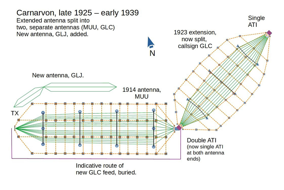
The first important realisation – which ‘official’ archaeologists had begun to understand in 2007 – was that the Carnarvon site didn’t just consist of a single antenna. By 1925, a total of three very low frequency (VLF) antennas faced into the wild winter storms of north Wales. Other antennas braved the same elements as part of the receiving site, around 30 miles to the south, in Towyn (since the late 1960s, known as Tywyn).
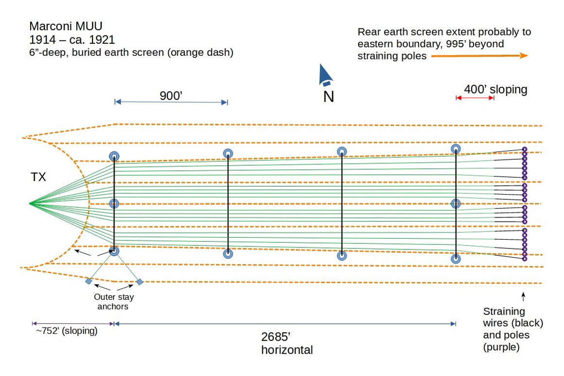
Around 1921 the first significant modification to the antenna system took place. The original earth screen system – effectively the ‘missing half’ of this antenna (the other half was the wire in the air) – was a run of wires buried around 6” in the boggy ground, extending beneath the whole width and considerably beyond the end of the antenna above.
Marconi knew of the importance of moist ground, which increases efficiency, but conceived of it as being a rather mystical “direct connection with the ocean”. This buried system was rather lossy and so was replaced with a vast, site-wide web of wire forming what was known as a counterpoise, elevated at around 24 feet by masts, 30 feet high. This was reported to significantly reduce losses. After a series of very long walks, for the first time, the layout of this counterpoise has been worked out.
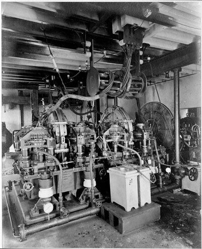
At this time, chaos had come to reign with transatlantic communication as a result of the seizure by the new Irish Free State, of two cable stations in County Kerry. This immediately left the financial markets producing an enormous backlog of communications that Marconi’s struggled to keep up with. Possibly in response to this development, Carnarvon’s antenna was extended by 900’, held up by two vast, self-supporting pylons of 60’ per side. Sadly, no photograph of these pylons has been found. Alexanderson alternators were installed at this stage, and valves were making an experimental appearance at the station.
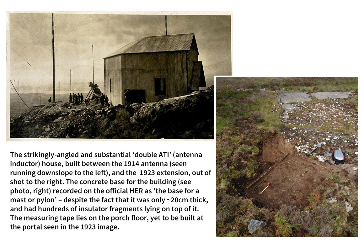
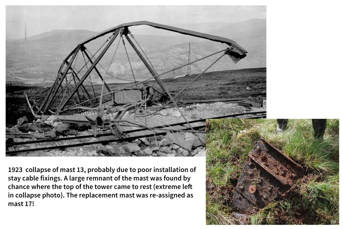
By early 1923, the pylons and the 900’ extension were already gone. Marconi’s had decided on a new, much more extensive, 2900’-long extension, also with an elevated counterpoise system, to the first, 1914 antenna. This ran from the summit of Cefn Du and the rear of the 1914 antenna, down the steep slopes of the other side of the hill, towards Llanberis, then, as now, a popular tourist destination. Again a broadly inverted-L design, it was held up by six steel lattice towers, also 400’ high. One – unlucky mast 13 – collapsed after completion, necessitating a rebuild and a new, luckier identification as mast 17! One man died in a separate mast-erection accident.
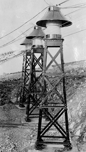
In the middle, between the two arrays of the extended antenna, a striking ‘double ATI’ (antenna tuning inductor) house was built. Inductors are coils of copper wire or tube that store magnetic energy as part of a resonating circuit. At the lower, Llanberis end of the 1923 array, a single ATI house containing more inductors was put up.
About a year later, further change was thought necessary. The two arrays were now split from one another, and a new feed was run from the transmitter hall up to the double ATI house. The 1923 antenna now operated (from valves) under the callsign ‘GLC’, whilst the original, 1914 antenna continued as ‘MUU’. The overwhelming volume of traffic for both was to America, despite GLC being completely unaligned with that direction – evidence that Marconi had by then understood his inverted-L antenna was not, in fact, directional in any meaningful sense.
By 1925, a further antenna – operating as ‘GLT’ – was reported to have been put up. The only reference to it was by R.N. Vyvyan, a senior Marconi engineer, in a book he wrote in 1933. No detail was provided then, and no remains of any bases are to be found at the site, nor any reference to it made in the archives. Until, one day, an obscurely-indexed folder was found, revealing 127 pages of detailed technical discussions about this ‘lost’ antenna. It became clear that ‘GLT’ was in fact ‘GLJ’. It was apparently built very close to MUU and, unsurprisingly, serious difficulties were experienced, due to strong interactions with the other two arrays. This led to a furious, months-long exchange of ideas between the Carnarvon and Marconi HQ in an attempt to solve the problems.
This included the installation of numerous new inductors.
Very early VHF beam experiments also took place at Carnarvon, which saw ranges of just a few metres achieved in experiments conducted in Rome being extended to the point where communication between Carnarvon and Dublin was possible. The work was then moved to Portsmouth, to further whet the appetite of an already-interested Admiralty.
In early 1939, with VLF having been superseded by short-wave beam systems, Carnarvon was closed. The site was dismantled and materials salvaged to the point where little remained.
I’m glad to say that, after not two weeks, but five months of fieldwork and archive searches, the site is now substantially better understood. I finished-off the work, by now 190 pages long, with some newspaper archive work. Stories of accidents, deaths, marriages and funerals all featured the north Wales Marconi stations, many due to the wartime presence of a fairly large contingent of soldiers guarding them. Even some ‘audio archaeology’ was discovered – a Welsh poem entitled ‘Chwefror’ (‘February’) told of a harsh and worsening winter, where those ten great iron pinnacles of Marconi’s 1914 antenna groaned in the strong winds.

My work, including a Google Earth overlay file of the site, has been deposited with the Royal Commission for Ancient and Historic Monuments in Wales and the Gwynedd Archaeological Trust, and the site has been proposed for scheduling.
Words: John Rowlands

Marconi’s Carnarvon Station 1914-1939
John has recently published the definitive history of the Marconi Carnarvon site as a 196-page, richly illustrated PDF-based book. £9.99 via Paypal, delivered straight into your inbox. Includes a free Google Earth-based interactive map of the site.


