


![]()

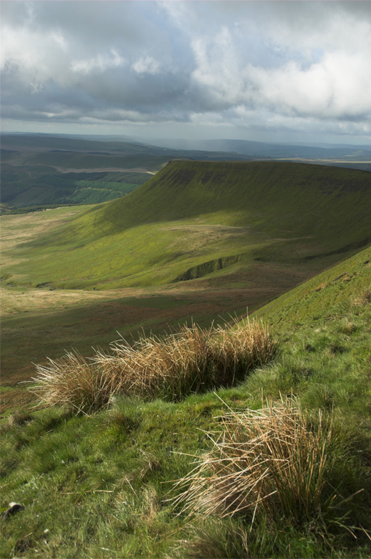
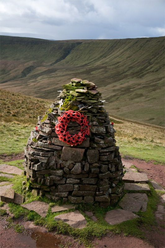
If a single walk could possibly encapsulate all that’s wonderful about the Brecon Beacons it would have to be this one. In just six miles it manages to squeeze in a little of everything, including an incredibly steep clamber up onto Craig y Fan Ddu, a long and enjoyable traverse of its magnificent skyline, a short sortie onto some of the featureless moorland that makes up a lot of the high ground of the National Park, and a walkout along a delightful, tumbling stream, jewelled with waterfalls and rapids. At the halfway point it offers huge views north over the eye-catching sweep of Cwm Cwareli to Brecon and beyond into mid Wales, and the memorial cairn beneath Cwar y Gigfran is as touching a place as you’ll find in the hills. Choose a good day to make the most of it all.
Walk back out of the car park and cross the cattle grid before turning immediately right and following a stone path steeply uphill. Continue past spectacular waterfalls onto the southern flanks of Craig y Fan Ddu. The path steepens noticeably as it approaches the top.
Once up, bear right and loop round onto the escarpment edge. Now follow the clear path all the way along the edge with stunning views down over the Caerfanell Valley below. Continue easily, climbing gently all the time, until your passage is blocked by a craggy niche carved out by the infant Caerfanell River. Cross it and follow a new path back onto the edge. Continue easily along the impressive skyline of Graig Fan Las until you reach a junction of paths at the very head of the valley.
Keep ahead for a great view over the stunning Cwm Cwareli and then backtrack to the junction where you now turn left (would have been on the right when you first approached) onto a narrow path that heads south-east towards a small crag at the edge of the moorland plateau of Waun Rydd. The narrow track drops slightly then traverses easily around towards the foot of this crag (Cwar y Gigfran), where you’ll find the memorial cairn and the remaining wreckage of the crash of Wellington Bomber MF509.
To continue, locate a steep gully that leads up the left-hand side of Cwar y Gigfran and climb this to the top where a good path leads right. Continue along the cliff edge, above the memorial, to a huge cairn that marks the southernmost tip of the escarpment. Your descent starts here.
Walk back from the cairn for a few metres and then turn left to follow the line of a small brook down for around 3m to join a clearer grassy track that traverses left and then drops directly down the spur in a deep grassy groove. This soon becomes an easy to follow footpath that crosses a broad featureless plateau to a junction by a wall. A right turn here will drop you the banks of the Caerfanell.
Cross the stile and follow the narrow path downstream, past a number of cascades and waterfalls. Eventually you’ll drop past the largest of the waterfalls to a footbridge. Cross this and hop over the stile ahead to follow a good track left past some ruins. After 100m, immediately ahead of a slab bridge, turn right and climb up into the forest. Follow the path steeply up, breaking left or right at will to view some of the many waterfalls, and eventually you’ll find yourself back at the car park.
Distance: 10km (6 Miles)
Time: 4/5 hours
Start/Finish: Torpantau (SO 056175)
Paths: Mainly clear paths over high mountains and alongside a river, a couple of sections that would be difficult in poor visibility, one or two boggy patches.
Maps: OS Explorer Series (1:25 000) OL12 Brecon Beacons
Tourist Info: Brecon TIC (01874) 622485, National Park Visitor Centre (01874) 623366


