


Across the world’s grasslands, farmers and ranchers are facing a growing challenge: how to keep their pastures healthy in the face of climate stress and land degradation. These issues often creep in quietly, showing up as bare patches or slower regrowth, until productivity begins to suffer. Once the damage sets in, reversing it can be difficult and costly.
Today, though, the answers are not only found on the ground. They are also coming from space. With the help of MODIS satellite imagery, land managers now have access to powerful tools that help them monitor pasture conditions from above. These insights allow them to catch early signs of trouble before they are visible in person, making sustainable grazing more achievable and effective.
What Land Degradation Looks Like on Grazing Lands
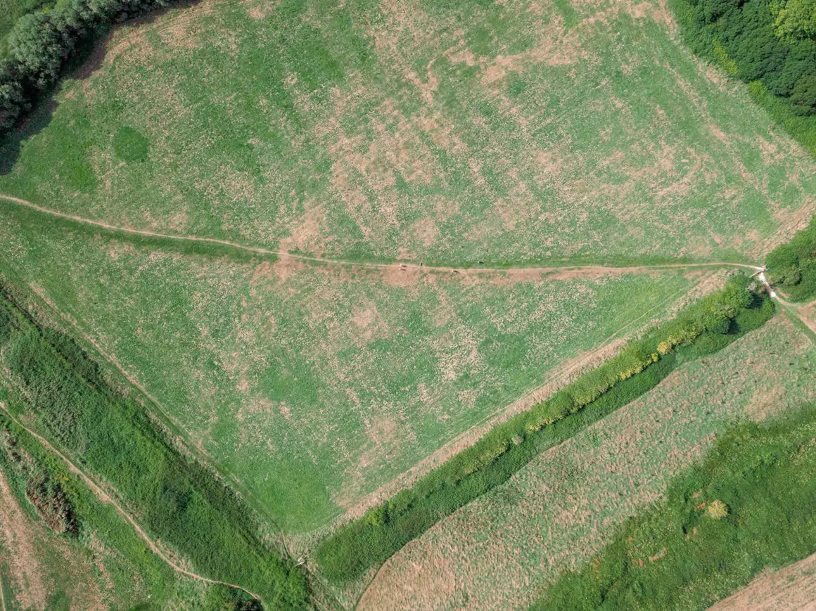
Land degradation in grazing areas goes beyond occasional poor growth. It refers to the long-term decline in a land’s ability to support healthy plant life and animal production. This includes soil erosion, reduced vegetation cover, loss of biodiversity, and in extreme cases, desertification. When pastures begin to degrade, they not only lose their productivity but also become more vulnerable to climate extremes.
Some of this damage results from natural factors like drought or shifting weather patterns. However, many of the problems are driven by human activity. Practices such as continuous grazing without rest, poor pasture rotation, and lack of land management planning can put unnecessary pressure on ecosystems.
What makes degradation difficult to tackle is that it often develops slowly and unevenly across large areas. Traditional field inspections might miss the early warning signs. Satellite tools offer a solution by detecting subtle changes in plant health, moisture, and soil conditions that would otherwise go unnoticed.
How Satellite Data Supports Smarter Grazing
Modern satellite sensors do more than capture images. They gather detailed information about vegetation health, soil moisture, and biomass growth. Indices like the Normalized Difference Vegetation Index (NDVI) help measure how green and healthy vegetation is. Others, such as the Normalized Difference Moisture Index (NDMI) and the Soil Adjusted Vegetation Index (SAVI), provide insight into stress levels, soil exposure, and moisture content.
This kind of data is especially useful for pasture managers who want to make more informed decisions. For example, NDVI maps can highlight areas of the land that are overgrazed, underused, or recovering well after rest. This helps guide rotational grazing plans and optimize the use of every field.
EOSDA LandViewer is among the tools that make it easier to apply these insights. With this platform, users can view and compare historical vegetation trends, apply custom filters for grazing analysis, and export data for integration with farm management systems. For those managing large or remote pastures, this kind of instrument becomes essential in maintaining healthy grasslands. Also, by relying on MODIS satellite data, which is constantly updated, land users can monitor changes over time and adapt their strategies based on up-to-date conditions. This creates a more responsive and precise way to care for rangeland ecosystems.
From Data to Action: Using Satellite Insights to Restore Land
The true value of satellite data lies in how it helps land managers take timely action. Rotational grazing becomes much more effective when it is guided by real-time observations. For instance, when the vegetation in one area shows signs of stress, livestock can be moved to another part of the land, allowing the stressed area time to recover.
Satellite images also help detect early-stage erosion, bare soil exposure, or the spread of invasive species. When identified early, these issues can be addressed before they become serious. During dry seasons, data from MODIS images can help guide decisions about livestock pressure, making it easier to avoid overgrazing when plants are struggling.
In a 2023 study conducted on large grazing areas, researchers evaluated the effectiveness of satellite-derived data, specifically using MODIS imagery, to estimate above-ground net primary production (ANPP) as an indicator of pasture growth. By comparing MODIS-based ANPP estimates with field measurements of herbage mass and growth rate across a rotational grazing system, they found that satellite data reliably captured longer-term trends in forage availability. This demonstrated that MODIS data can serve as a practical, low-cost tool to support grazing management decisions, particularly for monitoring pasture conditions over extended timeframes and large areas, where frequent field visits are not feasible.
The Broader Environmental Benefits
Sustainable grazing supported by satellite data brings benefits beyond individual farms. Healthier grasslands mean better soil structure, which helps retain water and resist erosion. They also store more carbon in both plants and soil, contributing to climate change mitigation.
Improved vegetation cover leads to better biodiversity, reduced runoff, and stronger ecosystems overall. These changes support global sustainability goals, especially those related to Climate Action, Sustainable Agriculture, and maintaining Land Degradation Neutrality.
In this context, the ability to download MODIS imagery or satellite viewers helps bridge the gap between scientific research and real-world application. Producers of all sizes, including those in remote areas, now have a way to monitor and care for their land with precision.
Looking Forward
Sustainable grazing is no longer just a concept. It is becoming a daily practice, powered by new tools and better information. With access to MODIS satellite images and platforms that make the data easy to understand, land managers are finding new ways to protect their pastures and restore degraded areas. These changes begin with a simple shift in perspective. By looking at the land from above, farmers and ranchers can see more clearly, plan more effectively, and respond more quickly.