


![]()
First view. An anchor centred in the Llanallgo roundabout heralding the approach to Moelfre. On the right is Paradwys Chapel. On the left is the lane to Lliwgy Beach. Ahead is a view, you’ll not forget. The road descends. Farmlands spread on either side. Farmhouses tuck down their lanes – some with sheep, some without. The tops of the village houses come into view and the sea rolls beyond – all the way to the horizon and the sky. On the right way, away in the distance, are ships waiting to go into port at Liverpool.
After a warm B&B welcome I wandered, exploring the village. The rippling of water tumbling down rocks drew me to the stream and its waterfall, sea-bound past the teashop and the Hindlea’s anchor, under the road and beyond the ice cream parlour. Further on, to my left is the heritage village pub and on my right, Moelfre Bay with a beach perfect for building shingle and pebble castles. The road swings uphill alongside the beach, T-junctioning on to another street of unique, specialty shops – antiques, clothing and wool. On the hillcrest overlooking the coast is the Royal National Lifeboat Institute – RNLI Museum and Gwylan Moelfre Sea Watch Centre. Since 1854, a lifeboat has been stationed here.
A life-sized, bronze statue stands at the front on vigil over the sea. A Moelfre legacy. The statue is of coxswain Richard Evans – Dic Evans, who captained the lifeboat, which saved the men on the storm troubled Hindlea heading for the rocky coast in 1959. It’s this ship’s anchor that stands in the village centre.
One hundred years before – 1859, it was the shipwreck of the Royal Charter. On route from Australia to Liverpool with passengers and gold – so close to journey’s end, the ship was embroiled in a mighty storm. It was impossible for all to be rescued as on the Hindlea, but thanks to Joseph (Joe) Rodgers (Giuseppe Ruggier) a few were saved. Braving the 100 mph plus winds, he left the floundering ship grasping a rope and scaled the cliff for help. Many of the 460 victims are buried in the graveyards of Moelfre and area churches and chapels – St Gallgo at Llanallgo, Penrhoslligwy and Paradwys Chapels.
")
- Giuseppe Ruggier | © Stephen McKay (cc-by-sa/2.0)
")
- Memorial sculpture to hero Joe Rogers (Giuseppe Ruggier)
Moelfre, meaning barren hill is a small, seaside village on the eastern end of Anglesey, but there is nothing small or barren about her story.
Steeped in history, steeped in stories of heroism, bravery, compassion and kindness as in the rescues mentioned. These are not the only tales. The first recording of the village is in 1157 linked to a sea battle between Anglesey seamen and Henry II’s English fleet. In 1306, it was named in the Doomsday Book of Wales.
Industry here has always been with the sea as a herring, fishing village and even boat building. The sea still gives. The population of under a thousand, swells in the summer months with vacationers coming for the day or longer. The area around Moelfre offers amidst its historic treasures, hiking, boating and sightings of all kinds, wildlife whether in the air (kestrels, red shanks, terns, fulmars, curlews, gannets) or the sea – dolphins (bottle-nosed and common) and porpoises.
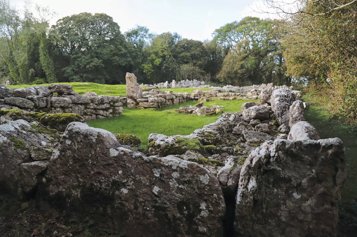
Back at the roundabout … Traeth Lliwgy Beach lane. Hedgerows thick with blackberries border the farm fields of sheep and cattle along this route. But, before the beach, there’s Lliwgy Cromlech – a Neolithic burial chamber, a barrow dated to 3000 BC. At its excavation in 1908, two separate groupings of human bones were unearthed. The massive 25-tonne capstone is on the left. Further along amidst a crop of trees is Din Lliwgy. An impressive, fourth century Welsh farm settlement of stone, built during Roman occupation. Not far, just across the field is Hen Capel, a 12th century chapel overlooking the coastal plain.
On Lligwy beach, the sand is soft and brown. Turning right, onto the Welsh Coastal path leads back to Moelfre Beach. Turning left, the path trails to Traeth yr Ora – a beach accessible only by boat or the footpath. A smugglers’ roost is its historic reputation! From here, one sees the island Ynys Dulas with her tower built in 1824 to store food and offer shelter for shipwrecked seamen.
Ynys Moelfre is another island (six acres or so) 200 metres off the Moelfre coast. Separated by Y Swnt – a narrow strait, the islet can be reached on foot at the low spring tide. Further along the Welsh coastal path is the Royal Charter Memorial with the sea revealing ship remnants at low tide.
Moelfre has an abundance of memorials both old and new. With a history of bravery at multi-levels embedded in community life, no one is forgotten. In 2015, the Commemorative Plaque honouring heroic villagers was unveiled – honouring sailors, fishermen, quarrymen… all who have answered the call.
Inland, another memorial stands in the form of a Celtic cross on the Morris family Brynefail farmland – a memorial to the Morris Brothers. They were strong supporters of the community and patrons of Welsh literature. In 1751, they founded the Cymmrodorton Society in London.
Moelfre is memorials plus more. Definitely not barren. Celebrating her past and living her present, offering something nautically unique and intangible – unflustered, ungarnished, restful. A salve to the soul.
Getting There
By car: The A 5114 from Langefni or the A55 from Holyhead to Bangor before turning north on the A5025.
By bus: Buses leave from Bangor, Llangefni. From Holyhead, change bus at Llangefni, number 62. Check the schedule.
By train: Via rail to Bangor or LlanfairPG, then take the bus.
By cycle: Have a look at the National Cycle Network… Anglesey offers so many splendid routes to Moelfre!
Words: Gillian Thomas
Feature image: Richard ‘Dic’ Evans | blogdroed (cc-by-sa/2.0)
First published in Welsh Country Magazine, Sept-Oct 2020


